Wildfire Management
What happens on land impacts the water
Fire has become a common occurrence in the CNMI. On the islands of Rota, Tinian, and Saipan, drought-like conditions from January to June lead to an increased vulnerability to fire. Grasslands in particular contain flammable vegetation that routinely ignite during these months. After a fire spreads throughout a grassland, the next rain erodes the now loose topsoil down slope into streams and the ocean. Through this process of sedimentation, the soil then spreads out over the seagrass and coral reefs in the form of sediment plumes, eventually smothering and killing large areas of habitat directly. Sedimentation on corals may also cause stress and contribute to coral bleaching.
What causes fires?
In other parts of the world, fire is a natural part of the ecosystem, removing invasive species, regulating native lifecycles, and facilitating nutrient cycling. In the CNMI fire seems to spread invasive species, restricting native growth and eventually scorching and eroding an area enough to produce badlands. Instead of natural causes, on Rota and Saipan hunters routinely set fire to the grasslands in order to draw deer to the resulting fresh vegetation growth. Saipan faces additional human-caused fires from tossed cigarette butts, garbage burning, and fireworks.
![]()
fire prevention and management
The Division of Coastal Resources Management and partners have been active in managing fires within the CNMI. Education campaigns such as “Real Hunters Don’t Burn” in Rota have been hugely successful in curtailing the among of fires started by hunters. Additionally, revegetation projects occurring in the Laolao and Talakhaya watersheds have decreased the damage that fires have on the landscape. By planting vegetation that have greater resistance to burning, we can convert these watersheds’ grasslands and badlands into forests that reduce the spread, strength, and number of fires.
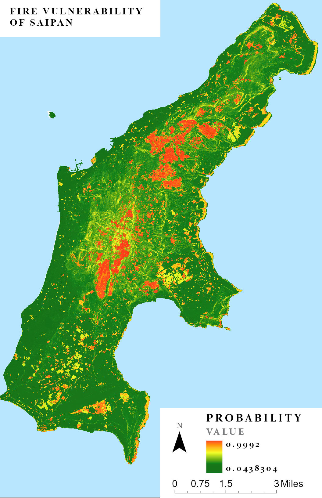
fire Vulnerability
Using previously collected environmental data and satellite imagery we can create models to predict where fires are most likely to occur throughout Saipan. The following map was produced by the CNMI Coral Fellow. The areas highlighted in red are the most vulnerable, which in this case means most similar in environmental conditions to an area where a fire occurred. Find methods and materials by clicking HERE.
*Note – Areas that are considered “Less Vulnerable” can still experience fires. Always practice good fire safety. (Click HERE for higher resolution map)
Spatial & Temporal Patterns of Fire
The 2019-2021 CNMI Coral Fellow conducted research identifying temporal and spatial patterns of fire on Saipan. Results indicate an increase risk of fire associated with grassland land cover, heightened by lower annual rainfall and particularly with increasing days without rain (i.e. drought conditions). Learn more about this work HERE (Bubb & Williams 2022).
Know Your Watersheds
Know your watershed! Click on a watershed below to learn more details about that watershed, including a “Report Card” of land-based sources of pollution.
Or, click here to explore the latest watershed data available in ArcGIS.
